Progress
Phase 1: Compilation and review of existing data
In the first instance, extant data were compiled and processed for the following areas: Bantry Bay, Waterford, Co. Louth, Belfast Lough, Cardigan Bay and South off the Isle of Man. Datasets from the Republic of Ireland (Bantry, Waterford, Louth), consist of high resolution bathymetry and backscatter multibeam (1x1m) and seismic pinger data. These data were collected between 2004 and 2008 as part of the Infomar (the INtegrated Mapping FOr the Sustainable Development of Ireland’s MArine Resource) programme, a joint venture between the Geological Survey of Ireland and the Marine Institute of Ireland.
Multibeam bathymetry and backscatter data were collected by the Royal Navy and the Agri-Food and Biosciences Institute in 2003 and 2009 over an extensive area from the mouth of Belfast Lough to Glenarm Point (Northern Ireland). The only seismic data available for Belfast Lough consists of a number of Chirp lines acquired by the University of Ulster in 1997.
There are no multibeam data available for the areas of interest in Cardigan Bay and off the Isle of Man. The British Geological Survey (BGS) have, however, supplied us with a number of scanned seismic lines acquired in the 1960s and 1970s. A large quatity of samples (cores and boreholes) have been recovered by the BGS in these areas over the past 50 years, the logs of which will be made available to the project.
A first scan of the existing regional scale datasets for features of interest (such as channels, cliffs and unconformities) allowed us to target more specific zones during the geophysical survey in 2011.
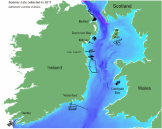
Phase 2: Geophysical survey 2011
The first field season of data collection was completed between 16th and 29th of June 2011, leaving from Bantry Bay and finishing in Belfast Lough. A ship-based marine seismic reflection survey, using a towed Boomer system and hull-mounted Pinger source, was undertaken onboard RV Celtic Voyager. Furthermore, multibeam data were collected in areas where no such data exists. Study areas targeted were: (i) Bantry Bay, (ii) Waterford, (iii) Louth and Dublin (Boyne), (iv) Cardigan Bay, (v) Isle of Man, (vi) Kilkeel, (vii) Dundrum Bay and (viii) Belfast Lough. Over 2000 km of seismic data were collected and subsequently process at Ulster University.
Please read the cruise report for further details about the cruise: PDF
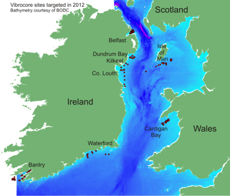
Phase 3: Coring cruise 2012
The second field season took place onboard RV Celtic Explorer from 10th to 20th June 2012, coring some of the targets recognised on the seismic lines. In total, 148 stations were cored using a GeoResources (6m barrel) vibrocorer. This resulted in 329m of sediment (with a mean core length of 2.22m). About 1/3 of these cores were split, logged and photographed on board.
Please read the cruise report for further details about the cruise: PDF
Phase 4: Processing and picking
Geophysical data processing, core analysis, foram picking and sample dating continues.
